A History
/SusquehannaRiver.jpg)

| Main Page |
| Time Line |
| History |
| Indian Trails and Shamokin (7000 BC-1763 AD) |
| Fort Augusta (1756-1792) |
| Founding of Sunbury (1772-1830) |
| Railroad and Canal Era (1830-1912) |
| Contemporary (1912-present) |
| Maps |
| Indian Trails and Shamokin (7000 BC-1763 AD) |
| Fort Augusta (1756-1792) |
| Founding of Sunbury (1772-1830) |
| Railroad and Canal Era (1830-1912) |
| Contemporary (1912-present) |
| Special Topics |
| Related Links |
| Works Cited |
The Great Shamokin Path |
|
. |
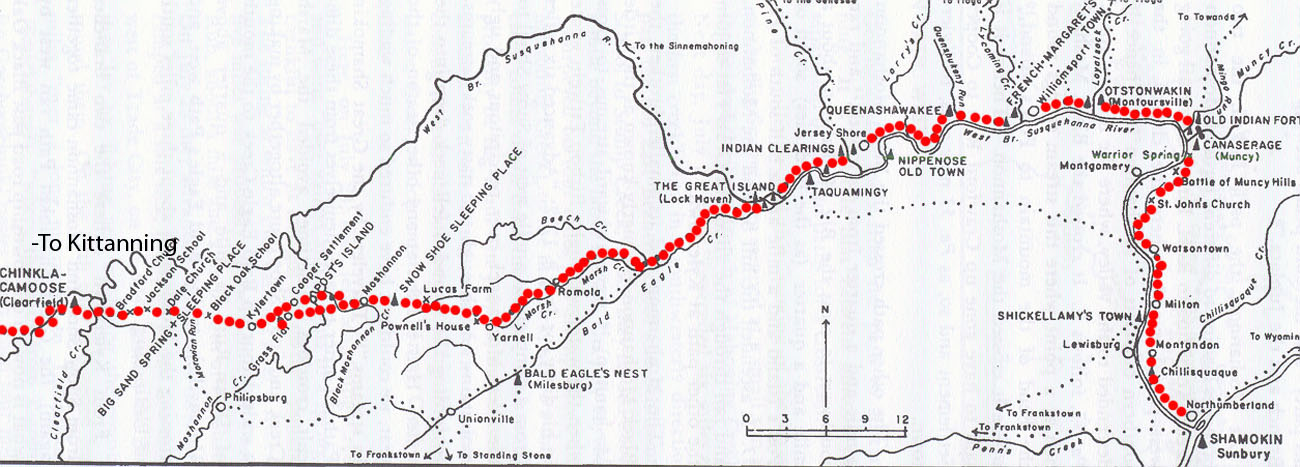
The Great Shamokin Path is considered to be the most famous of all the Indian trails, chiefly because it connected the two largest Indian towns in Pennsylvania: Shamokin and Kittanning. The path also served as a connection between the Susquehanna and Allegheny Rivers and according to historian Charles A Hanna was “the earliest path used by the Pennsylvania Indians in their journeys from the Susquehanna to the Ohio.” Furthermore, it was a crucial navigation tool for the Delaware and Shawnee warriors during the French and Indian War, enabling them to recover much of the eastern land they had lost. Unlike many of the trails, which were often traveled by European explorers and settlers, the Great Shamokin Path is unique in that it was used only by Indians. |
Parts of The Great Shamokin Path are now followed by Pa. 147 through Milton; Pa 405 near Watsontown; U.S. 220 through Montoursville, Williamsport, Linden, Jersey Shore, Lock Haven, and Blanchard; Pa 144 and Pa 53 near Snow Show and Moshannon; Interstate 80 through Woodland; U.S. 322 through Clearfield; Pa 879 through Curwensville and Gramplan; U.S. 219 through Luthersburg; and along parts of S.R. 1006, 1001, 2007, 2014, 1002, and 4007, Pa. 210 and Pa 954. It crossed the Clearfield Creek in about the same spot as US 322 crosses today and at present day Lock Haven, where it forded the Susquehanna it was part of a junction point which united several other important Indian Paths. |
|
..
. Taken from Indian Paths of Pennsylvania, Paul A.W. Wallace |
|
|
||
|


The Bucknell Environmental Center ▪ 835 Fraternity Road ▪ Bucknell University ▪ Lewisburg ▪ PA 17837▪ (570) 577-1490