|
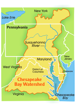
(Map courtesy The Pennsylvania Department of Environmental Protection) |
For centuries the Susquehanna was used as a source of nourishment, protection, travel, trade, and reverence by Native Americans who inhabited its coastlines. For approximitely 11,000 years before white encroachment the Susquehannocks, an Iroquois-speaking tribe of the Northeast, arrived in the area, birthed a civilization, and came to control the land around the Susquehanna. The area has become much of what it is today due to those first inhabitants, and furthermore, the Susquehanna still holds major iinfluence over the lives of those within the watershed.

- Flows 444 miles from its headwaters at Otsego Lake in Cooperstown, N.Y., to Havre de
Grace, Md., where the river meets the Chesapeake Bay.
- Is the largest tributary of the Chesapeake Bay, providing 50 percent of its fresh water flows.
- Is the longest, commercially nonnavigable river in North
America.
- Is the largest river lying entirely within the United
States that drains into the Atlantic Ocean.
- Is almost one mile wide at Harrisburg, Pa.
- Flows about 20 miles per day on an average summer day.
- Has a normal flow of about 18 million gallons per
minute at Havre de Grace, Md.
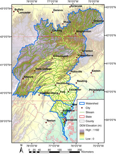
- Drains 27,510 square miles, covering
half the land area of Pennsylvania and
portions of New York and Maryland.
Includes all or portions of 67 counties.
- It comprises 43 percent of the
Chesapeake Bay's drainage area.
- The basin is comprised of six major subbasins.
- It has more than 49,000 miles of
waterways – rivers, streams, creeks,
brooks, runs, etc.1
- The basin is made up of 69 percent forest lands.2
- The area has a population of nearly 4 million.3
- Is home of the native Brook Trout fish
species.
- Is one of the most flood prone areas in
the entire nation, experiencing a major
devastating flood on average every 14
years. The basin's average annual flood
damages is $150 million dollars.
(Fact sheet courtesy of the Susquehanna River Basin Commission)
1 source National Hydrography Dataset, 2 source
Chesapeake Bay 2000 landuse data, 3 source 2000 Census
|